Trip Report: Paddle on the East Branch of the Penobscot River from Bowlin Camps to Hay Brook
Story and photos by Sam Deeran, Friends of Katahdin Woods and Waters
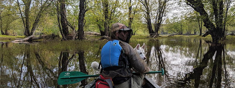
On the drive to Medway, Maine, my friend Audrey and I realized it was ten years ago, to the day, that we had made our first journey into the Maine woods together. You can travel far and wide, but the Maine woods will always bring you together again. We were joined on our trip by three other companions: my friend Kate, her partner Ryan, and Audrey’s husky-shepherd mutt Fiona.
We were making our way to Medway where we’d meet with Galen Hale. Galen is a Katahdin Region Renaissance Man; he owns a stove shop, operates a scrap yard with his brothers, and for decades has shuttled trips on the Allagash and Penobscot Rivers. He’s downsized his fleet of canoes in the past 20 years, winnowing from 60 boats to about a dozen. When we arrived in Medway, he had two sturdy Old Town Discovery 169s strapped to his pick-up rack.

I’ve had the good fortune of getting to know Galen while coordinating this river trip, which took us 25 miles on the East Branch of the Penobscot River from Bowlin Camps to Hay Brook. Galen reminds me that the history of the region lives in the telling of the folks that have called it home for years. In an hour and a half drive with Galen, my friends and I got a grand tour of the region and its history, inspired by waypoints along our drive on the Katahdin Woods and Waters Scenic Byway.
We arrived that night at Bowlin Camps to a warm welcome from the caretaker David. We took a little walk across the Bowlin Bridge and north on the International Appalachian Trail. Excited for the adventure ahead, we dimmed our cabin’s propane lights and hit the hay early that night.
The water was running high that weekend, about 2,000 cubic feet per second. Cubic feet per second, or cfs, is a reading take of the river’s width, depth, and speed, but a number alone doesn’t give an image of the river. David told us that as the water came down from around 3,000 CFS the day before, a new island out front of the camps had emerged.
Loading up our canoes, we had our first and last man overboard – or dog overboard as it were – while loading Fiona into the canoe. Just weeks earlier, river expert and NEOC proprietor Matt Polstein had told a group of paddlers and me about how the most dangerous time in a canoe was often during and just after a put-in.

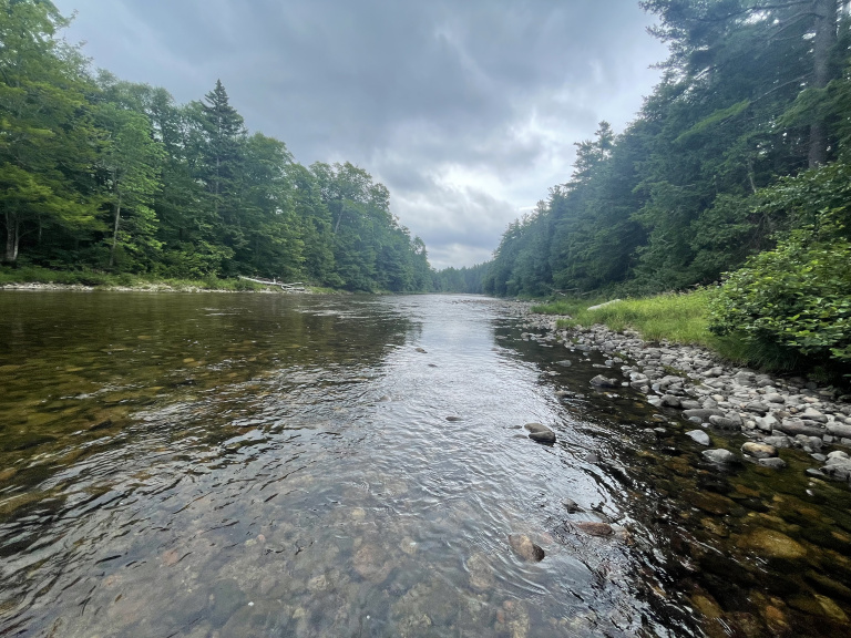
Starting downriver, the water was quick and wavy below Bowlin Bridge. We passed the Spencer Rips, which most old maps indicate is a single set of riffled water or Class I rapids. It might be easier to just anticipate riffles and Class I rapids intermittently from Bowlin Camps until the river flattens into the silver maple floodplain above and below the confluence with the Seboeis River, a stretch of about 10 miles.
We moved swiftly along. Part of my task on the river was to ground-truth new draft maps and river descriptions in the Three Rivers Paddling Guide. The guide, a collaboration between Friends of Katahdin Woods and Waters and Maine Woods Forever, is available for paddlers eager to run the river and test the map this summer. I had imagined checking in on exact mileages, but the water was just too quick to pause and ascertain my GPS coordinates. I adjusted my expectations and went for ground-truthiness instead. Each feature on the map was indeed there and the maps read intuitively.

Near the Fiske Brook campsite, the river was high enough that it ebbed into the joining stream, creating a dead water which we explored looking for moose and birds. Just as we gave up on the chance of a wildlife sighting and turned our attention to the water downriver, a sloshing noise drew our attention to the north. A moose calf crossing the river. As we loaded into the boats, a bald eagle swooped overhead. Stop looking and you will see.
Aside from campsites, downriver from Bowlin Camps there’s only one human structure, a cabin perched on an embankment where the river briefly curls north about a half mile above the confluence of the Seboeis and East Branch. South of there, the river runs through the magnificent silver maple floodplain. It’s a rare and endangered ecosystem where during high water, the river floods over the massive roots of the silver maples. As we entered the floodplain, the paddling became a bit more work. Where before most of our work was managing the canoe’s direction, now we had to labor to push it forward. We took our time. Since our launch we had paddled for about two hours and already traveled eight miles. While enjoying the slower paddle, a second bald eagle – or maybe the first again – swooped overhead.
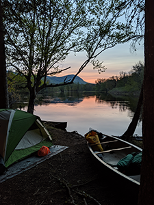
We settled into the Big Seboeis campsite, which looks north to the Seboeis and East Branch confluence and the rocky head of Lunksoos Mountain, the second big peak on the International Appalachian Trail. After pitching our tents, we set out to explore the surrounding woods where we found painted trillium wildflowers and the medeola virginiana. We gently dug to the roots of the medeola virginiana to reveal the white tuber below. It tastes a bit like a cucumber. Foraging is allowed in Katahdin Woods and Waters National Monument, but only for personal consumption. One medeola root per traveler and we turned back to camp to cook the food we carried in.

Back at the shores of our campsite, we were greeted by an approaching boat with a small onboard engine. There was Galen, his friend Lee, Lee’s son Adam, and their dog Harley. Harley and Fiona were fast friends; the humans, too. Galen and Lee had brought along a cooler with some cold refreshments, an unanticipated luxury for a river trip. Galen, Lee, and Adam were happy to report that it was the first weekend that brook trout were biting. A cold spring had delayed their activity. Waving from the shore, we said our goodbyes, Fiona staring off to the river and her departed pal Harley.
It wasn’t long before another dog, and her human keepers made their way to our shores. From our campsite we saw three boats come down from the Seboeis River. They had paddled eighteen miles from Grand Lake Road to Big Seboeis campsite in just one day. As their boats made it to shore, a paddler with her face obscured by a black bug net inquired, “Audrey?” Audrey and the paddler had met a few times before at the Homestead, a Portland music venue. We got to know the crew of Seboeis paddlers before they made camp of their own. Big Seboeis campsite – a place for rivers and people to meet.

The next morning, I woke in the early morning dark to birds like I had never heard before. An uncountable number, singing their songs, sometimes in rhythm, sometimes not. I left my tent to watch the world wake up along the shore of the East Branch. As I left the shore to return to my tent, I caught a glimpse and heard the slosh of a moose leaping from out of the water onto the western shore. I returned to my tent and tried to sleep while the sky was still its foggy, navy blue.
We set out early into the morning fog after a simple breakfast. Paddling the flat water from Big Seboeis, we passed Lunksoos Camps, the historic site of Dacey Farm and the spot from which a collapsed Donn Fendler was spotted after being Lost on a Mountain in Maine. Less than a mile south from there, we came past the confluence of the East Branch of the Penobscot and the Wassataquoik Stream. In less than three miles, three rivers run together: the East Branch of the Penobscot River, the Seboeis River and the Wassataqouik Stream.
At the historic site of Hunt Farm, the river bends west and then shortly after south. From there, we were hawkeyed looking for a portage takeout on river-right. We were approaching the first rapids of a set of two at Whetstone Falls. Before we could see the rapids, we heard them echoing up through the river valley about a half mile. With the water running high, the rapids were churning something fierce. The sky was turning a pale sprawling gray, a sense of foreboding growing as the river’s jumping waters became our only focus on the horizon.

We pulled off at a tiny, beachy embankment on river-right, protected from the downstream maelstrom by a sharp rocky outcrop sticking out into the river. From there, we walked down along the rapids, a long, continuous stretch of Class II waves. It takes scouting from several locations to come up with a good course. There was a good, calm lane on river-right, but the way was blocked by a ledge with a big drop. We decided to start center-right and work river-right if we could.
When we set out on the trip, our plan had been to portage Whetstone Falls, each of us being cautious about one another’s paddling experience. A day and a half into the trip, confident of our own paddling and our fellow paddlers, we decided to run this first set. My heart quickened and my eyes sharpened to the challenge ahead. As we set back out upriver from our scouting walk, we saw our fellow paddlers from the night before approaching the portage. We were eager to yield the beach for their safe passage to shore. We swapped water for the high shore as they made their way down to the scouting lookouts to watch our descent.
For better or worse, your intuition takes over when the water quickens and the rapids start dragging you downriver. With Fiona perched on the front of the boat, we had an exhilarating, rollicking ride down the rapids, mostly along center-right – the water being too powerful for us to track too much to the right to that clear lane. From there, the river bends left down towards the even louder set of second falls below Whetstone Bridge. There’s a large pool between the two sets of rapids and we made quick work cutting to river-left to a beach where we set our canoes to go scout the second set of rapids. Looking from the shore and then atop Whetstone Bridge, we scouted the Class III rapids. The approach looked good from river-left, but from there we wanted to track an ambitious diagonal, straight towards less turbulent water between the center two pyres of the bridge.

Buoyed from the adrenaline and confidence from the first set of rapids, we took to the boats and made our descent. Starting river-left was no problem, but neither boat made it very far river-right – and we risked exposing the boat’s side to the pressing waves by forcing the issue. We each splashed through a massive wave at river-center but made it through with a dozen or so gallons of water in our boats to show for it. Below the falls, we rafted up, sharing the exhilaration of our safe descent, deswamping our boats, and sharing some peanut butter and jelly sandwiches to reenergize after adrenaline had run us ragged.
From below Whestone Falls, the river winds through the Penobscot River Trails land, privately operated by a charitable foundation supporting the Maine Outdoor Education Program and year-round biking, cross-country skiing, snowshoeing, and paddling on the property. We spotted a few bikers on the riverside trails. It’s a lovely, calming part of the river, slowly ambling through myriad eddies and islands, and little riffly water.
About an hour and a half before our designated meet-up time with Galen, we made it to the Hay Brook takeout at the southern end of the Penobscot River Trails land. As if on command, the mosquitoes hatched, launching an assault which even our trusted bug head nets couldn’t withstand. Within minutes both cheeks had a fresh bite, swelling to a lump – always the biggest bumps on the year’s maiden mosquito bite. Galen and his pick-up truck came to our rescue within ten minutes of our take-out. He always arrives early to a pick-up, anticipating most folks move quicker than they’d expect along the river.
Riding back to Medway with Galen, we talked about the days to come, when more paddlers come to explore the river. Things have been relatively quiet on the remote waters of the East Branch, but then again, the secret of the paddling and fishing here has been out for a long time. The native Penobscot Indians have been paddling these waters since time immemorial and in 1857, a Penobscot guide named Joe Polis led Henry David Thoreau down the East Branch. On the river, our thoughts belonged to the moment and our companions, but writing now, I’m humbled to think of the peoples whose paths we followed.

As more people come to witness the wonders of the Katahdin Region, Galen hopes his fleet of boats will grow once more. He’s got some good land just north of the confluence of the East Branch and the West Branch, where he hopes to put some cabins for folks looking for a nice play to stay – to enjoy the Penobscot River Trails, the East Branch of the Penobscot River, and Katahdin Woods and Waters National Monument.
Friends of Katahdin Woods and Waters and Maine Woods Forever invite you to help ground-truth the Three Rivers Paddling Guide and to offer your feedback to be incorporated into its 2021 publication. The map is available via mail or email. To request a copy or to get help with planning a trip of your own, please contact Sam Deeran, Deputy Director, at sam@friendsofkww.org