PRESS RELEASE
CONTACTS:
BRIAN HINRICHS,
EXECUTIVE DIRECTOR
FRIENDS OF KATAHDIN WOODS & WATERS
brian@friendsofkww.org
LUCAS ST. CLAIR,
PRESIDENT
ELLIOTSVILLE FOUNDATION, INC.
FOR IMMEDIATE RELEASE – May 23, 2023
Friends of Katahdin Woods & Waters Announces $35M Capital Campaign
KATAHDIN WOODS AND WATERS NATIONAL MONUMENT – Friends of Katahdin Woods & Waters is publicly launching A Monumental Welcome, a $35 million fundraising campaign for Katahdin Woods and Waters National Monument. The campaign has three goals: providing funding for a visitor contact station, priority park projects, and Wabanaki-directed projects. $22.8 million has been raised to date.
The campaign will fund Tekαkαpimək Contact Station at Katahdin Woods and Waters National Monument. Funds for this goal also support a new 3.6 mile access road to the site, an eastern lookout, a network of accessible paths and access routes, and state of the art off-grid sustainability features.
Tekαkαpimək translates from the Penobscot language to “as far as one can see” and is pronounced de gah-gah bee mook. Katahdin Woods and Waters National Monument is located within the present and traditional homeland of the Penobscot Nation. The land and waters hold special significance to the Penobscot Nation and are inextricably linked with Penobscot culture, ceremonies, oral traditions, language, history, and indigenous stewardship which continues the respectful relationship with the land and waterways that has gone back more than 11,000 years. Katahdin is a culturally significant place to the Wabanaki people where connecting watersheds provide important travel routes for Wabanaki people, comprised of Maliseet, Mi’kmaq, Passamaquoddy, and Penobscot Nations.
Time-limited “Reserved Rights” were written into certain deeds of land allowing for Elliotsville Foundation, Inc. (“EFI”) to construct a visitor contact station on Lookout Mountain. EFI is partnering with a Wabanaki Advisory Board with representatives of the independent Native Nations that constitute the Wabanaki Confederacy – Houlton Band of Maliseet Indians, Mi’kmaq Nation, Passamaquoddy Tribe at Motahkomikuk and Sipayik, and Penobscot Nation. Together, the partners are building a visitor contact station in consultation with the National Park Service that reflects the peoples, natural resources, and future of the Katahdin region.
“Our family is honored to support the next step for Katahdin Woods and Waters National Monument, constructing the Tekαkαpimək Contact Station as a gift to the National Park Service and visitors for generations to come,” said Lucas St. Clair, President of Elliotsville Foundation, Inc. “Through artistry and exhibits created by Wabanaki artists and knowledge keepers, visitors to Katahdin Woods and Waters National Monument will receive a profound welcome.”
The campaign will also fund $2.7 million in priority park projects for the National Park Service. Projects already funded include a renovation of the Mile 6.4 Loop Road Overlook, a sign plan, night sky programming, road maintenance, and more.
“I appreciate the efforts by the Friends of Katahdin Woods & Waters and Elliotsville Foundation Inc., in beginning this capital campaign. Funding through the campaign will facilitate priority park projects at Katahdin Woods and Waters National Monument, affecting cultural and natural resources, planning efforts, maintenance of facilities, and ongoing work involving roads and trails,” said Mark Wimmer, Superintendent of Katahdin Woods and Waters National Monument. “We look forward to working together to implement these projects to support the development of the monument.”
The campaign’s final goal establishes a $1 million fund for Wabanaki projects as defined by the Wabanaki Advisory Board. The early vision for this fund is to create career pathways for Wabanaki youth. Final funding decisions will be made by the Wabanaki Advisory Board.
The Wabanaki Advisory Board collectively spoke to the projects and campaign: “We as a Wabanaki Advisory Board have been mutually committed to fostering a collaborative partnership with EFI that is needed to create the Tekαkαpimək Contact Station while developing a long-term relationship that will carry into the future.”
With the launch of the campaign, Friends of Katahdin Woods & Waters is inviting all those who love Katahdin Woods and Waters National Monument and communities connected to it to support the campaign. The campaign thus far has been made possible by over 200 donors led by leadership gifts from Roxanne Quimby Foundation, Elliotsville Foundation, Inc., Burt’s Bees, L.L. Bean, the National Park Foundation, and NorthLight Foundation. The Quimby Family Philanthropies, Roxanne Quimby Foundation and Elliotsville Foundation, Inc., have challenged donors to take part in this historic campaign with a $10 million commitment.
“Friends of Katahdin Woods & Waters is proud to play our part in this campaign in partnership with the National Park Service, Wabanaki Advisory Board, and Elliotsville Foundation, with the support of our growing philanthropic community,” said Brian Hinrichs, Executive Director of Friends of Katahdin Woods & Waters. “This campaign provides immediate economic impact, with over 90% of construction expenditures here in Maine, and we look forward to welcoming new visitors who will support the ongoing revitalization of local communities.”
To contribute to the campaign, interested donors can visit the campaign webpage or contact Friends of Katahdin Woods & Waters staff for more information.
Katahdin Woods and Waters National Monument was created by Presidential Proclamation on August 24, 2016. The 87,500 acres of land was donated to the United States by Burt’s Bees founder Roxanne Quimby through Elliotsville Foundation, Inc. to mark the centennial of the National Park Service. In 2020, the Monument was recognized for its brilliant dark skies and is the first International Dark Sky Sanctuary on the U.S. eastern seaboard.
The contact station is being built in cooperation with the National Park Service, Wabanaki Advisory Board, Friends of Katahdin Woods & Waters, Elliotsville Foundation, National Park Foundation, and other stakeholders. Contractors include Wiphunakson LLC, Saunders Architecture, Alisberg Parker Architects, Atelier One, Haley Ward, Inc, Reed Hilderbrand, Transsolar Inc, Allied Engineering, Inc., Tuhura Communications, Jennifer Neptune (Penobscot), WeShouldDoItAll (WSDIA), Split Rock Studios, DCL, Emery Lee & Sons Inc., OBP Trailworks, LLC, Wright-Ryan Construction, Erin Hutton Projects, and Stern Consulting International.
The Tekαkαpimək Contact Station site is an active construction zone and is closed to visitors at this time. The public will be welcomed in summer 2024.
###
What’s New
Posted: August 29, 2023 by Sarah Andre
My Park Story – Elise’s Summer Reflections
Friends’ place-based educators connect learners with land year-round, but long summer days outside the structure of a school day allow for deeper youth experiences on our trails and rivers. Education Coordinator Elise Goplerud shares her reflections on the impact of these programs in this month’s #myparkstory.
Katahdin Learning Project’s summer youth programs wound down in August with our final hurrah–an overnight canoe trip. Most of KLP’s programs this summer were part of a collaborative series in partnership with local non-profits Katahdin Gear Library, Outdoor Sport Institute, and Katahdin Area Trails. Collectively named the Katahdin Region Outdoor Collaborative (or KROC, pronounced Kay-Rock), we offered eight introductory-level outdoor adventures to more than 200 middle and high schoolers at no cost. The spirit of togetherness shone in the programs and students, as we saw participants returning for more sessions. Each time, youth came in more engaged and more willing to take on leadership responsibilities. This summer, we hiked Barnard Mountain in the national monument, mountain biked on the trails at Hammond Ridge, spent the night at Lunksoos Camps, paddled in the Debsconeag Wilderness Area, and got silly as we walked to the Ice Caves. We explored highlights of the Katahdin region’s North, South, East and West. The kids experienced places they’d never been before and realized how much is in their backyard. I can guarantee you won’t hear any of these students say, “there’s nothing to do here”.
The kids had plenty of downtime to enjoy the woods without technology (and we didn’t hear any complaints!). However, many evenings also included guided discussions about how to recreate responsibly outdoors, plus storytelling around the campfire or while gazing at the stars. The students learned some history of the conserved lands that we visited, the many types of management styles, as well as the importance of protecting land for wildlife and recreation. Our reflections got deeper throughout the season. A student who first arrived shy and unsure of the outdoors (our first trip, his least favorite part: hiking) was taking on leadership roles, volunteering answers to questions, and seeking more ways to get involved. In his own words: “It just feels really, really good to be out here in the wild”.
On that final canoe trip, the scheduled paddle was modified due to wind and we had more downtime at camp than we expected. The leaders quickly huddled to brainstorm activities so the kids wouldn’t get bored. But before we could actually do any of these activities we saw kids digging in the sand, collecting firewood, and looking more content and at peace than we could have predicted. Free play is a hot buzzword in nature-based education but it’s generally in the context of toddlers and pre-K to early elementary students. We rarely talk about the importance of free play for older students or adults. Free play came so naturally to these middle schoolers– I believe in part because they did it on their own. No leader told them “it’s time to free play so get it in while you can” as in a school setting where their lives, including “free” play, is very structured. Genuinely free play with no time limits, rules, or boundaries made the difference. Leaders were shocked during the debrief when a kid said that one of his favorite parts of the entire program was not the games and activities we played but “how much freedom we gave them.”
There was something different and amazing about these programs that you don’t see on day programs with the schools. I saw a hunger for wilderness and freedom that I hadn’t seen with the other groups we work with. Sometimes in this line of work I get discouraged because I’m told by some teachers and parents, and we hear in the media, that “kids just aren’t interested in the outdoors anymore. They only want to spend time on technology”. But this summer proved to me that those people are wrong. Youth do want to be out here and connection to nature is just as innate as our ability to breathe. Youth just need the opportunity to be in the wilderness, take on responsibility, exercise creativity, and be a little wild.
Learn more about Katahdin Learning Project and view the 2023-2024 program catalog for Katahdin Region school districts.
All photos: Credit FKWW
Posted: August 15, 2023 by Sarah Andre
Inflation Reduction Act to Invest in Katahdin Woods and Waters National Monument
Inflation Reduction Act to Invest in Katahdin Woods and Waters National Monument
Date: August 8, 2023
Contact: Jeanne Roy
Patten, Maine – This year, Katahdin Woods and Waters National Monument will build on past efforts to restore and improve aquatic passages (culverts and bridges) for Atlantic salmon with $138,461 in funds received from the Inflation Reduction Act. This restoration project is part of a nationwide effort to restore natural habitats and address climate change impacts. In fiscal year 2023, President Biden’s Investing in America agenda, through the Bipartisan Infrastructure Law and the Inflation Reduction Act, will provide $52 million to the National Park Service to fund projects throughout the country related to ecosystem resilience, restoration, and environmental planning needs.
Over the past several years, park managers and staff have built durable bridges and culverts to improve Atlantic salmon habitat that has been degraded over time through aging infrastructure and effects from flooding. The additional funding will double these efforts by increasing the number of passage improvements and habitat restorations. Atlantic salmon will have greater access to breeding grounds, food resources and cool water refugia. Improved passage will also restore natural flow regimes and will benefit sensitive wetland resources, aquatic and terrestrial habitats and recreation sites up and downstream of the projects.
“We are pleased to enhance Atlantic salmon habitat for the benefit of the greater Penobscot River watershed,” said Superintendent Mark Wimmer. “Investments from the Inflation Reduction Act will help us provide this project with needed infrastructure for many years to come.”
The projects announced today infuse much-needed funding to put people to work addressing critical ecosystem needs to restore healthy and resilient park lands while benefiting communities surrounding parks. Through the Bipartisan Infrastructure Law and Inflation Reduction Act, the National Park Service is working to address the impacts of the climate crisis, including intensifying drought, wildfires, flooding and legacy pollution in national parks and other public lands. Resources are making significant strategic investments to repair critical facilities and infrastructure and enhance conservation through ecosystem restoration and recreation opportunities.
The full lists of fiscal year 2023 projects are available online: IRA Restoration and Resilience projects and BIL Ecosystem Resilience projects.
Posted: July 27, 2023 by Sarah Andre
Don’t blink! – July eNewsletter
Woods and Waters Day, youth outdoors, Seboeis paddle trip, and more…
Summer is in full swing, and despite the damp weather, we’re taking advantage of each precious summer day while it’s here. And it’s hard to believe with our minds and hearts fully in summer mode, but we just wrapped up our spring fundraising season last month. This spring, we challenged the Friends community to help us hit our ambitious membership goal of $75,000. We’re delighted to report that fundraising to support Friends’ ongoing operations and programs this spring totaled $85,634, 114% of our goal! This annual membership support is vital for ensuring that experiences like those you’ll read about in this newsletter are possible for educators, youth, art enthusiasts, and paddlers–not just today, but for years to come.
Looking ahead, we’ll be gathering with our Friends community in just under a month with an evolution to our traditional anniversary celebration that we’re calling “Woods & Waters Day.” We hope you’ll join us at Shin Pond Village for lunch and live music, then head into the monument with us later in the afternoon for a sneak peek at Tekαkαpimək Contact Station before it opens to the public in 2024. Learn more and register for Woods & Waters Day here.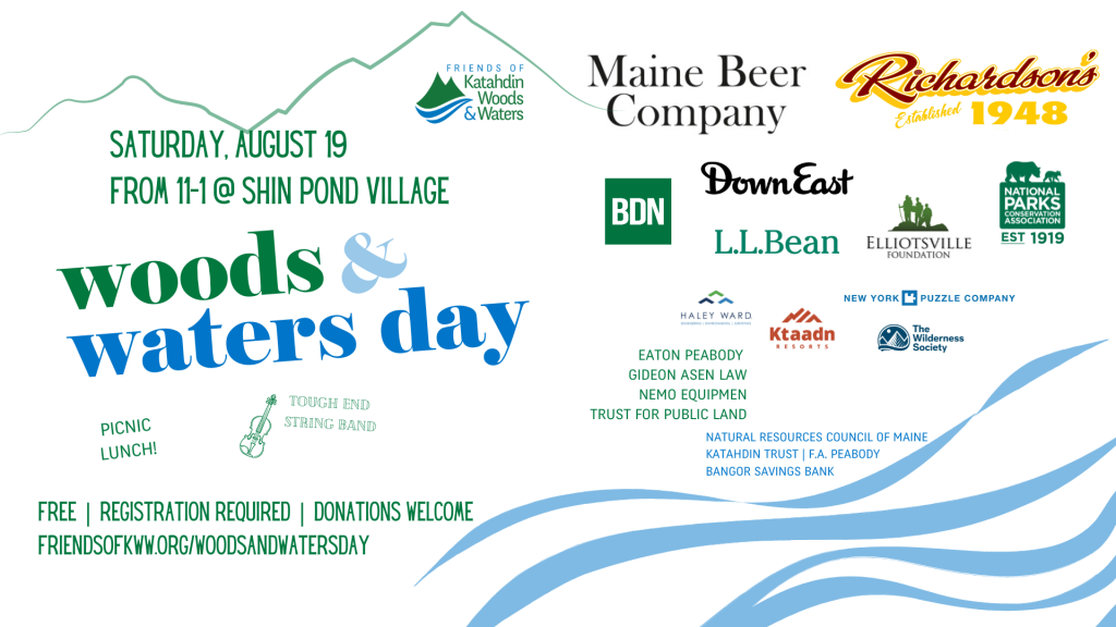
#myparkstory/#yourparkstory
This month, our featured Park Story comes from Maggie O’Hara, Katahdin Learning Project’s seasonal place-based educator. Maggie just graduated from Katahdin Middle High School and is headed to Eastern Maine Community College to study secondary education in the fall.
“Going out in the woods is not every high schooler’s dream. And being entirely honest, at the beginning of last fall it was definitely not on my top ten things to do. The idea of big hikes, intense canoeing trips, and dealing with nature’s wrath truthfully scared me. But then, I was offered to run a fundraiser at one of Friends of Katahdin Woods and Waters programs: Stars Over Katahdin.”
Teacher Camp 2023 – Focus on Wabanaki Studies
We are still glowing with gratitude after KLP’s annual Teacher Camp last month. Always a valuable opportunity for learning, this year had a special focus–LD291–the 2001 law requiring the teaching of Wabanaki history and culture in Maine classrooms. Teachers from around the region and state explored integrating Wabanaki studies into school curricula and the purpose and history behind the law. Wabanaki REACH provided a program to expand their understanding of Wabanaki history and present issues. A hands-on map activity helped each individual delve into the important “unlearning” and subsequent learning necessary for educators preparing to incorporate the truth in structures where Wabanaki history, culture, and ways of knowing have been erased. Teachers left empowered with knowledge generously shared by Heather Augustine (Elsipogtog First Nation Canada) of REACH, Nolan Altvater (Passamaquoddy), the Special Projects Coordinator for the Passamaquoddy Historic Preservation Office, and Angie Reed, Water Resources Planner with Penobscot Nation Water Quality.
Nolan’s keynote spoke to the importance of infusing Maine studies with past and present Wabanaki contributions in a culturally competent manner, sharing truth and acknowledging the harmful narratives that previously existed and still persist today. Teaching materials and resources, created with the help of presenters, were shared in attendee folders and at a resource table. Supporting teachers in their ongoing learning and next steps was an important objective of the day. Most importantly, KLP and Friends hoped to spark individual commitments to the process of unsettling our educational systems and centering Wabanaki peoples in determining how their stories are told. To learn more or request resources, please contact Education Director Kala@friendsofkww.org.
The Outdoor Classroom
Surviving the halls of middle school can be tough enough, but KLP was impressed by 6th-8th graders from Southern Aroostook Community School earlier this summer when they learned the importance of wilderness survival skills and safety. On the first day, they learned what being prepared looks like and what to bring with them on a trip. Students crafted various forms of shelters ranging from debris huts to tarps to tents. On day two, they covered team-building, fire starting, and first aid. Kids learned the importance of working together when faced with an emergency. The two days capped off with a thoughtful conversation about careers in the outdoor field, and we can’t wait to see some of these kids on the trail when they are rangers, foresters, or guides!
Just last week, KLP was joined by NPS Ranger Crystal at Lunksoos Camps’ picnic area for a river ecology lesson with Katahdin Elementary’s Summer Academy. Kids learned about habitats, the very special food web of the silver maple flood plain, and played a salmon game, too. Kudos to the teachers who make summer learning a priority–and have enough bug nets to go around!
Trip Report – Spotlight on Seboeis
Despite, nay, because of, all the rain we’ve received this year in the Katahdin region, Friends’ staffers Sam and Elise, along with Elise’s partner Joe, enjoyed a late season run of the Seboeis last month. If you missed Sam’s delightful trip report on social media, find it here–and if you are curious for more details or would like to ground-truth the Three Rivers Paddling Guide (working copy), reach out to Elise@friendsofkww.org. With summer rains, the Seboeis continues to run high much later this season. Check the USGS monitoring site, ensure good water levels, and consider a trip!
“As Far As One Can See” at Portland Museum of Art
On Friday, June 30, at 6 PM, the Portland Museum of Art hosted “As Far as One Can See: Visitor Contact Station Rises in Katahdin Woods and Waters” to a full auditorium with standing room only. Friends thanks the panelists: Gabriel Frey (Passamaquoddy), Jennifer Neptune (Penobscot), Todd Saunders, and Lucas St. Clair, who provided lively conversation and insights. The program was punctuated with stunning visuals of this unique project, the creation of a Visitor Contact Station in Katahdin Woods and Waters National Monument reflecting a Wabanaki worldview, which will be a gift to the U.S. National Park Service and open to the public in 2024. To learn more and join the campaign in support of this project and more, visit friendsofkww.org/a-monumental-welcome
NPS News and Notes
Ripple Effect
Sponsor Spotlight
This month we are shouting out The Wilderness Society, a new sponsor in 2023 with special interest in supporting one specific event, Teacher Camp! We thank them for their generous sponsorship at the Deasey level. Learn more about TWS and their mission here. And thank you to Natural Resources Council of Maine for your Hathorn level sponsorship and support since 2018!
Sponsors provide crucial funding that supports our mission and work. To learn more about becoming a sponsor in 2023, visit friendsofkww.org/sponsorship or contact sarah@friendsofkww.org.
—This blog post was adapted from an email transmitted on July 27, 2023. Sign up for our email list at friendsofkww.org/signup.
Posted: July 25, 2023 by Sarah Andre
My Park Story – Maggie’s Stars Over Katahdin
This featured Park Story comes from Maggie O’Hara, Katahdin Learning Project’s seasonal place-based educator. Maggie just graduated from Katahdin Middle High School and is headed to Eastern Maine Community College to study secondary education in the fall.
Going out in the woods is not every high schooler’s dream. And being entirely honest, at the beginning of last fall it was definitely not on my top ten things to do. The idea of big hikes, intense canoeing trips, and dealing with nature’s wrath truthfully scared me. But then, I was offered to run a fundraiser at one of Friends of Katahdin Woods and Waters programs: Stars Over Katahdin.
At that time, I was not looking forward to the scenario: out in the middle of the woods selling cookies to whoever would pass. But once I was there, gasping at the thousands of stars I saw through the telescope, I made a realization. Being outside doesn’t always mean long hikes or kayaking out in a lake, but it means to simply enjoy the natural world away from your home.
We were cautioned to stay off our phones and to try not to use any form of unnatural light (so that everyone could see the stars). So my phone-driven brain was already expecting the worst. But, as the night went on, I slowly forgot about the little computer that was in my back pocket.
Some of my friends came to help out with the bake sale and I was able to take a walk to where telescopes were scattered across the field behind Taylor’s Katahdin View Camps. I was amazed at the sight that traveled ahead of me. Trails sticking out around the field, apple trees fencing the trails, the orange autumn leaves that now looked like different shades of gray from the night, and most importantly: the stars.
Thousands of stars littered the sky above us. It almost felt like you were walking into one of those fish aquarium tanks. The ones that had fish swimming above your head? Yeah, walking out from the trail into that field felt like walking into a sea of stars. I swore I had never seen so many stars in my life. My friends that had followed along ran past me to the telescopes that didn’t have people stuck at them yet; specifically, the ones that were set to look at planets. But even if you weren’t looking through the advanced telescopes, you could still lay back against the grass and point out the shapes your brain made with the stars. Did I already say it took my breath away?
In that moment, watching my friends sprint around the field showing each other what each telescope held made me realize the beauty of outdoors. The seasonal autumn feel against the beauty ahead of me began my love for the outdoors. And I think my friends fell in love too, without even realizing it.
Sure, Taylor’s Katahdin View Camps isn’t directly on the monument, but it still symbolizes the mix of community and nature that we strive for. Katahdin Woods and Waters hosts other kinds of events that are similar to this. These kinds of activities are a wonderful opportunity to give people a chance to be outdoors even if they are not ready for the “big hikes”.
Posted: June 30, 2023 by Sarah Andre
Ebb and Flow – June eNewsletter
A guide’s East Branch #parkstory, teen adventures, park upgrades, paddling safety, and more…
The calendar has officially declared that summer has begun, but our bodies and heads might not believe it yet. We’ve endured a tenacious pattern of wet, cool weather in the Katahdin region and across Maine. Some things are as we expect them to be: the lady’s slippers are in bloom, deer antlers are soft with velvet, and the chorus of hungry songbird chicks plays on repeat in the forest. The Maine Turnpike and Route 1 are increasingly thick with cars on Friday afternoons as they are each summer, but each year a few more make it up to the monument and region. We talk about change this month in a #myparkstory chat with legendary Maine Guide Kevin Slater. Read on to learn about an exciting collaborative effort to get 6-12th graders into the woods and plant the seeds of what their future careers could be in the Katahdin Region.
Whether you live next to the national monument or are dreaming of your first trip, we encourage you to check out the resources on our website at friendsofkww.org/visit, and if you still have questions, drop us a line! Because we know memories of a lifetime are made in the north Maine woods, we invite you to make new memories this summer at Katahdin Woods and Waters.
My Park Story – Inspired by the National Park Service, throughout the year we are sharing stories of meaningful place-based experiences in Katahdin Woods and Waters.
In 50 years of paddling the East Branch of the Penobscot, he’s learned that every paddling trip is a new experience–and he is an important witness to changes that slowly span the decades. In a recent conversation with Kevin Slater, co-owner of Mahoosuc Guide Services, he talked about the crucial data to watch when planning a river trip, the importance of water safety, and the historically low water levels in northern Maine rivers this spring.
Join us on social media: post your adventures on Facebook and Instagram with the hashtags #MyParkStory and #KatahdinWoodsAndWaters.
A Monumental Welcome reaches audiences far and wide
It’s been just a month since Friends hosted our announcement of A Monumental Welcome campaign in Bangor. We are thrilled with the response from our community and from those learning about Friends and Katahdin Woods and Waters as a result of the news coverage. Wabanaki Advisory Board and A Monumental Welcome steering committee member Natalie Dana-Lolar spoke of the importance of “tendrils” reaching out into the world from Tekαkαpimək–and through this campaign, we are proud to be a part of this historic effort. We invite you to learn more and become a part of A Monumental Welcome.
Woods and Waters Day – Join us on Saturday, August 19th
Friends’ annual celebration of the designation of Katahdin Woods and Waters National Monument has a new name: Woods and Waters Day! We have also moved the party from an evening celebration to lunch so that more folks from around the state can plan a day trip for the event. Expect great food, live music (Orono’s Tough End String Band), and good company from 11 a.m. to 1 p.m under the pavilion at Shin Pond Village in Mt. Chase. And there’s more: on this day only, the public can get a sneak peek at the new Tekαkαpimək Contact Station during a special open house in the afternoon. Save the date–we’ll share more details and registration soon. Hope to see you there!
Friends and NPS get on the water!
Last week, Friends’ staffers Meghan, Kala, and Elise spent the day canoeing with NPS on the East Branch of the Penobscot River. They put in (fittingly) Old Town Penobscots at Lunksoos Camps and paddled down to the Whetstone Bridge. Along the way, Pack Raft Maine founder and guide, Alejandro “Alex” Strong, provided incredible instruction. Alex is a strong advocate for the monument and was eager to hear from NPS about park improvements in the works. On the water, he began with the basics, such as parts of a paddle and paddle techniques. As the day progressed, the instruction became more advanced. The crew p
ulled over above some rapids to scout and learn how to read the water and navigate whitewater successfully. They learned safety and rescue techniques should an emergency arise on the river. It was a fun and meaningful day for Friends and NPS–paddling together and challenging themselves in the whitewater.
It’s been an unusually dreary spring, yes, but recent rainy weather has also brought unexpected recreational opportunities- canoeing, fishing and taking in the vivid green foliage at its peak. After a disappointing April, the Seboeis River filled with rushing water in late May to provide a second chance for a run. We can’t wait to share a trip report with you next month!
Teen Summer Adventures with Katahdin Learning Project
School is out across the region, but KLP staff will have just a moment to catch their breath before gearing up for a busy summer! Education Director Kala Rush, Education Coordinator Elise Goplerud, and seasonal Place-Based Educator Maggie O’Hara (hired as a recent graduate of Katahdin High School!) will be on the trails with local youth in collaboration with several community non-profits. In a series of introductory-level, inclusive day and overnight trips, rising 7th-10th graders will learn about the natural world and their own strength and resilience while hiking, paddling, mountain biking and camping in the Katahdin Region. This program is supported in part by the Maine Department of Education’s Forestry Stewardship and Career Pathways grant program, and is an embodiment of KLP’s and Friends’ commitment to the strategic priorities of building relationships and deepening impact on youth through place-based learning in the national monument and region. Local parents of teens–there are spaces remaining! Choose one or sign up for all six here.
Park News – NPS Hires, trail improvements, and Overlook planning!
Friends reached out to Katahdin Woods and Waters’ Facility Operations Specialist, Christopher “Dewey” Loft, for a glimpse into park operations heading into the summer. Wow! Check out these highlights below, and if you are headed into the monument this summer, be sure to say “thank you” to the park service staff working to keep your experience safe, accessible, and fun while protecting the natural and cultural resources on the land.
Katahdin Woods and Waters welcomes Robert Weaver as the new Maintenance Worker Supervisor–helping Dewey better manage KAWW’s many roads, trails, and facilities. He joins the team with 14 years experience of roads and trails construction and management. He comes most recently from Sequoia National Park in CA, and they are very excited to have him on the team.
The Trails Crew is working hard to clear the trails of blowdowns from this last winter. As of last week, all trails had been cleared except for the stretch of the International Appalachian Trail (IAT) from Bowlin Camps to one mile south of Deasey, and “this last section should be finished any day.”
On June 26th, the six-person crew from Maine Conservation Corps will arrive for the season! This year, they will work on the IAT segment that runs through the national monument by opening up the trail corridor and correcting signage to make the trail much more user-friendly.
NPS maintenance is set to begin work on the Lynx Pond trailhead. Work will include making a connector trail from the parking lot to the ADA trail and building an ADA parking space near the trailhead.
Perhaps the most-photographed spot in the monument, the iconic Overlook at mile 6.4 on the Loop Road is getting a makeover. A final design plan has been contracted and will include ample parking spaces and improved traffic flow for vehicles and pedestrians. Future visitors will have access to ADA restrooms and trails, as well as some interpretive exhibits. Construction should begin by mid-summer 2024. The Overlook project is one of many priority park projects funded by A Monumental Welcome!
Ripple Effect
Sponsor Spotlight – Thank you to Lookout level sponsor L.L.Bean! A lead contributor to A Monumental Welcome capital campaign, proud supporter of making the outdoors accessible to all, and a great Friend.
Sponsors provide crucial funding that supports our mission and work. To learn more about becoming a sponsor in 2023, visit friendsofkww.org/sponsorship or contact sarah@friendsofkww.org.
—This blog post was adapted from an email transmitted on June 22, 2023. Sign up for our email list at friendsofkww.org/signup.
Posted: June 28, 2023 by Sarah Andre
Trip Report: Seboeis River Paddle
Outside good cell service, away from wall clocks and computers, there are many ways to experience time in Katahdin Woods and Waters National Monument. Alternative time-telling questions in this neck of the woods include: Have the fiddleheads come up? Which wildflowers are growing? How are the blackflies? And one of my favorites, what’s the water level on the Seboeis?
Education Coordinator Elise Goplerud, her partner Joe (an arborist and darn-good tree identifier), and I paddled the Seboeis River at around 350 cubic feet per second (“cfs”). By the Gregorian calendar, it was June 11, 2023.
350 is a good number to set your clock for (so to speak). It’s a sweet-spot for a Seboeis river trip. You can check the river levels here on the USGS website.
While we took this trip mostly for fun, we couldn’t help but think of what that 350 number means for Friends of Katahdin Woods & Waters’ in-development Three Rivers Paddling Guide. The guide recommends paddling at flows no less than 100 and no greater than 600 – though those lower flows can mean dragging your boat and the higher flows can intensify the challenge of the early rapids.
At 350 cfs, you can make a day trip of the Seboeis River from Grand Lake Rd to Lunksoos Camps, paddling around 20 miles in anywhere from four to seven hours. Make sure to leave ample time for shuttling cars and canoes. We opted to leave a car at Lunksoos Camps and bring our cars and canoes northward. In the parking lot, we met some anglers eager to drop a line for brook trout in the Seboeis’ cool pools. There are many shuttling formulations and if you want an assist, there are local lodges that will help with the back and forth.
That day, we put in around 10:30, snaking past some poison ivy (abundant on road- and river-sides) as we carried boats to the water. Putting in at Grand Lake Rd is something I’d recommend for intermediate paddlers experienced with class II rapids. Here’s why.
The water tugs you downriver from the moment you set off from the shore and it isn’t long before you’ve glided through a long stretch of rocks and rapids. The water quickens as you go, and soon you’ll need to make a swift pull-off before the crash and tumble of Grand Pitch. A large rock on river-left, and the rolling boom of water audible from the gorge below, signals it’s time for a portage. Watch out for the signage, but don’t count on it – black bears like to tear these things down. Our trio felt that given the remoteness of the trip, the repetition of rapids, and the danger of the upcoming Grand Pitch, that this first stretch qualifies as class II whitewater.
The portage is a beautiful spot to unwind from the first stretch of rapids and heavy-boat-carrying. You’re sitting at a confluence of the Davis Brook and Seboeis River, beneath the Grand Pitch and with a stunning view of Sugarloaf Mountain (not the famous ski resort – though the significant site of a fossil discovery that helped prove plate tectonics).
After the portage, there are some riffles of near-rapids, though, generally you’re settling into a flow that in all my time paddling feels so unique to the Seboeis River. It’s always pulling you gently downriver, saying something I hear like “here friend, I have something to show you.”
I have something to show you. One thing the river had to show this time around was the new Snowshoe Lodge, built along the Seboeis Riverside Trail to invite winter travelers to stay among a cheery woodstove and cots on a first-come, first-serve basis. Joe and Elise parked on the riverside to check it out. I pinned against some grasses until the river tugged me downriver for more fun.
I have something to show you. Tiny, tiny brooks – easier to hear than see, covered in summer brush and streaming forth from the gorge walls. Moose – crashing and clumsy through the riverside woods. Deer – bounding with their white-tails bouncing above the ferns. A bald eagle – tracking our way downriver, taking to the air and perching always a long look ahead.
I have something to show you. Not everything the river has to show was obvious to my eyes and ears, and I was grateful to have Joe and Elise as observant paddling companions. We marveled together at the trees in this river corridor – cherry, American elm, the biggest tamarack I’ve ever seen, and towering, thick pines. You’re left to wonder how they survived their many years. Does this special river feed special trees?
For paddlers wary of rapids – though eager to enjoy the Seboeis River – the Philpott Snowmobile Bridge provides an excellent put-in. Whether as a starting point or a passing landmark, I love this intersection of river and bridge. It’s a great snapshot of the Katahdin Region, a place where snowmobilers and paddlers both pass in bliss.
An important side note here: parking is a bit challenging nearby the put-in. The park service is working on it, and in the meantime, be prepared with a high-clearance four wheel drive vehicle.
It feels like the river slows down as you near the end of the Seboeis River and the confluence with the East Branch of the Penobscot. I wondered if the East Branch was full enough that it was back-filling and slowing down the Sebeois. My arms may just have been tired.
I didn’t mind slowing down because as you reach the confluence you enter the Silver Maple Floodplain. Bending, thriving, sprawling, twisting, and breaking silver maples surround you in all directions, draped over lush floodplains of ferns. Two or more trees often lean towards one another from opposing riverbanks, creating a series of arches that invite you through a gateway. Through this gateway, you’re welcomed to the widening flow of the East Branch of the Penobscot River.
As we entered the expanse of the lower East Branch, with wider vistas in sight, we could see haze on the horizon. Another indicator of time – on a larger scale than a season or year – that told us fires burned en masse to the north. I took one last picture at Lunksoos Camps, a red sun shining through the haze. While we stepped off from the East Branch, I could still feel the gentle pull of the Seboeis River.
The clock on the Seboeis said something like 300 cfs, and still I could hear Here friend, I have something to show you.
– Report submitted by Projects Director Sam Deeran. Photos contributed by Sam & Elise Goplerud.
Note: the in-development Three Rivers Paddling Guide is available for paddlers to navigate the East Branch, Seboeis, and Wassataquoik. Please reach out to Elise Goplerud at elise@friendsofkww.org for a copy. We ask paddlers trying out the map to help us ground-truth the information and send feedback after their trip. We’re also happy to provide practical advice on shaping your paddling trip.
Posted: June 22, 2023 by Sarah Andre
My Park Story – Kevin Slater on the East Branch
In 50 years of paddling the East Branch of the Penobscot, he’s learned that every paddling trip is a new experience–and he is an important witness to changes that slowly span the decades. In a recent conversation with Kevin Slater, co-owner of Mahoosuc Guide Services, he talked about the crucial data to watch when planning a river trip, the importance of water safety, and the historically low water levels in northern Maine rivers this spring.
Long before the designation of the national monument, Kevin first paddled the East Branch in 1973–and the following year, began guiding others on the river as a Registered Maine Guide. (Learn more about Kevin, his partner Polly, and Mahoosuc Guide Services here.)
“It’s all beautiful,” he chuckled preemptively before I could ask him to name a favorite spot. His love for the river is expressed in his intimate knowledge and respect for it.
“The most demanding and technical section is from Matagamon to Bowlin Camps, where in one roughly two-mile stretch there are nearly half-dozen Class 2 rapids and four carries.” Ever the teacher, Kevin explains, “it’s just like it sounds. Take your boat out of the water and carry it around.” He emphasized the difference between falls and pitches: “Be aware that an experienced paddler can run the fall. But the pitches are carries.” Kevin punctuated this warning: “A number of the pitches occur right before a blind turn in the river.”
Kevin recommends the upper section of the East Branch for paddlers experienced with rapids and carries–and for those who are not, to “employ the services of a guide.”
Guides like Kevin monitor the CFS, or cubic feet per second, of water entering the East Branch through the Matagamon Dam*. Higher CFS means deeper, faster water and more exciting (and potentially dangerous) paddling. While outdoor recreationists are well aware of the unpredictability of conditions, when we spoke in mid-May Kevin’s voice was slow with gravity.
“Every year is different. 2023 is historically low.” While southern Maine rivers ran high this spring, water levels in northern Maine rivers from the St. John to the Penobscot were “the lowest I’ve ever seen,” he reported. Low snow, earlier spring thaws, and dry summers in the region are factors that Kevin attributes this change to. A guiding trip planned for the St. John the week prior was changed to the Allagash instead, where enough water flowed to carry a canoe along.
Among the things that have NOT changed much, apparently, is Kevin’s desire to be on the water. This summer, he’ll be on the East Branch for three trips taking fisheries biologists on a NOAA grant-funded study of Atlantic Salmon habitat. It’s tricky to catch him on the phone or by email, and he has a habit of leaving you with a taste of something really intriguing. In my inbox is a teaser “if you’re interested” about a federal salmon hatchery in the 1930s and the history of the old East Branch guides. Definitely interested–and look forward to catching up with a bona-fide part of the history of the East Branch and KW&W in the off-season. Thanks, Kevin!
*Data available from the Matagamon Lake Asscociation, to whom Kevin encourages East Branch paddlers provide membership support. His sweet spot for “really good paddling where you’re not a pinball” is 550-900 CFS at the dam.
Posted: June 5, 2023 by Sarah Andre
Friends in Bloom – May eNewsletter
Greetings from the executive director, a monumental campaign, gates open, and more…
My name is Brian Hinrichs and I’m writing to you as the new executive director for Friends of Katahdin Woods and Waters. I want to start by thanking the incredible staff and board of Friends for the warm welcome over the last few weeks, and express my sincere excitement for what’s to come–including meeting many of you! Now in my third week, it is clear I have joined the organization at a time of significant growth and opportunity, as our big announcement earlier this week makes clear (read more below!). With gates opening, trees budding, and Friends planning their spring and summer adventures, there is much to look forward to.
See you on the trails,

Brian Hinrichs, Executive Director
Capital Campaign Announcement – Friends, together with Elliotsville Foundation, Inc., the NPS, and a Wabanaki Advisory Board, gathered in Bangor with lead donors, partners, and members on Tuesday. In case you haven’t seen the news, we announced the launch of A Monumental Welcome, a $35 million fundraising campaign for Katahdin Woods and Waters National Monument. The campaign has three goals: providing funding for a contact station, priority park projects, and Wabanaki-directed projects. Read the official press release here on our blog. We invite you to be a part of giving every visitor A Monumental Welcome; to learn more, please contact Development Director Meghan Cooper at meghan@friendsofkww.org.
Visiting in Spring –
Spring at Katahdin Woods and Waters is a special time. Black flies have arrived along with the trillium, trout lilies, and fiddleheads. All are reasons to celebrate the resilience of the Maine woods! Did you know: black flies require clean, moving water to breed? The East Branch watershed provides ample and ideal habitat for the larvae, which are important food for fish, turtles, and tadpoles. When the flies mature, our native birds and bats depend on them as a food source.
Fortunately, on the water is one of the best places humans can find some reprieve from the maddening swarms. In spring, the rivers run high and swift, providing excitement perfect for experienced paddlers at the northern end of the river. Kevin Slater of Mahoosuc Guide Services has been running the East Branch since 1973, and cautions that only experienced paddlers comfortable with rapids and carries should attempt the stretch from Matagamon to Bowlin–or employ the services of a guide. Friends’ Projects Director Sam recommends the trip from Lunksoos up to the Seboeis River confluence and back anytime from now through foliage season for an accessible day trip with no rapids! For more inspiration, contact elise@friendsofkww.org for suggestions and a digital “in-progress” version of our Three Rivers Paddling Guide.
Learning and Growing – Friends’ Katahdin Learning Project is abuzz this season, providing empowering, place-based experiences in the national monument and our communities.
Friends’ annual Teacher Camp will be held this year on June 20th at the Stewart Learning Center in Lincoln. This year’s camp will offer educators a deep dive on integrating Wabanaki studies into school curricula, the purpose and history behind LD 291, and participation in a Wabanaki REACH training session to deepen their understanding of Wabanaki history and present issues. Teacher Camp is open to all Maine public school educators. Registration is required and scholarships are available.
Park News
Ripple Effect
Sponsor Spotlight
This month we thank our Katahdin level sponsor, Richardson’s Hardware. A longtime and generous Friend, Richardson’s is not only the place for hammers and potting soil, but bug nets and kayaks, too.
Sponsors provide crucial funding that supports our mission and work. To learn more about the benefits of becoming a sponsor, visit friendsofkww.org/sponsorship or contact sarah@friendsofkww.org.
—This blog post was adapted from an email transmitted on May 26, 2023. Sign up for our email list at friendsofkww.org/signup.
Posted: May 22, 2023 by Sarah Andre
Friends of Katahdin Woods & Waters Announces $35M Capital Campaign
PRESS RELEASE
CONTACTS:
BRIAN HINRICHS,
EXECUTIVE DIRECTOR
FRIENDS OF KATAHDIN WOODS & WATERS
brian@friendsofkww.org
LUCAS ST. CLAIR,
PRESIDENT
ELLIOTSVILLE FOUNDATION, INC.
FOR IMMEDIATE RELEASE – May 23, 2023
Friends of Katahdin Woods & Waters Announces $35M Capital Campaign
KATAHDIN WOODS AND WATERS NATIONAL MONUMENT – Friends of Katahdin Woods & Waters is publicly launching A Monumental Welcome, a $35 million fundraising campaign for Katahdin Woods and Waters National Monument. The campaign has three goals: providing funding for a visitor contact station, priority park projects, and Wabanaki-directed projects. $22.8 million has been raised to date.
The campaign will fund Tekαkαpimək Contact Station at Katahdin Woods and Waters National Monument. Funds for this goal also support a new 3.6 mile access road to the site, an eastern lookout, a network of accessible paths and access routes, and state of the art off-grid sustainability features.
Tekαkαpimək translates from the Penobscot language to “as far as one can see” and is pronounced de gah-gah bee mook. Katahdin Woods and Waters National Monument is located within the present and traditional homeland of the Penobscot Nation. The land and waters hold special significance to the Penobscot Nation and are inextricably linked with Penobscot culture, ceremonies, oral traditions, language, history, and indigenous stewardship which continues the respectful relationship with the land and waterways that has gone back more than 11,000 years. Katahdin is a culturally significant place to the Wabanaki people where connecting watersheds provide important travel routes for Wabanaki people, comprised of Maliseet, Mi’kmaq, Passamaquoddy, and Penobscot Nations.
Time-limited “Reserved Rights” were written into certain deeds of land allowing for Elliotsville Foundation, Inc. (“EFI”) to construct a visitor contact station on Lookout Mountain. EFI is partnering with a Wabanaki Advisory Board with representatives of the independent Native Nations that constitute the Wabanaki Confederacy – Houlton Band of Maliseet Indians, Mi’kmaq Nation, Passamaquoddy Tribe at Motahkomikuk and Sipayik, and Penobscot Nation. Together, the partners are building a visitor contact station in consultation with the National Park Service that reflects the peoples, natural resources, and future of the Katahdin region.
“Our family is honored to support the next step for Katahdin Woods and Waters National Monument, constructing the Tekαkαpimək Contact Station as a gift to the National Park Service and visitors for generations to come,” said Lucas St. Clair, President of Elliotsville Foundation, Inc. “Through artistry and exhibits created by Wabanaki artists and knowledge keepers, visitors to Katahdin Woods and Waters National Monument will receive a profound welcome.”
The campaign will also fund $2.7 million in priority park projects for the National Park Service. Projects already funded include a renovation of the Mile 6.4 Loop Road Overlook, a sign plan, night sky programming, road maintenance, and more.
“I appreciate the efforts by the Friends of Katahdin Woods & Waters and Elliotsville Foundation Inc., in beginning this capital campaign. Funding through the campaign will facilitate priority park projects at Katahdin Woods and Waters National Monument, affecting cultural and natural resources, planning efforts, maintenance of facilities, and ongoing work involving roads and trails,” said Mark Wimmer, Superintendent of Katahdin Woods and Waters National Monument. “We look forward to working together to implement these projects to support the development of the monument.”
The campaign’s final goal establishes a $1 million fund for Wabanaki projects as defined by the Wabanaki Advisory Board. The early vision for this fund is to create career pathways for Wabanaki youth. Final funding decisions will be made by the Wabanaki Advisory Board.
The Wabanaki Advisory Board collectively spoke to the projects and campaign: “We as a Wabanaki Advisory Board have been mutually committed to fostering a collaborative partnership with EFI that is needed to create the Tekαkαpimək Contact Station while developing a long-term relationship that will carry into the future.”
With the launch of the campaign, Friends of Katahdin Woods & Waters is inviting all those who love Katahdin Woods and Waters National Monument and communities connected to it to support the campaign. The campaign thus far has been made possible by over 200 donors led by leadership gifts from Roxanne Quimby Foundation, Elliotsville Foundation, Inc., Burt’s Bees, L.L. Bean, the National Park Foundation, and NorthLight Foundation. The Quimby Family Philanthropies, Roxanne Quimby Foundation and Elliotsville Foundation, Inc., have challenged donors to take part in this historic campaign with a $10 million commitment.
“Friends of Katahdin Woods & Waters is proud to play our part in this campaign in partnership with the National Park Service, Wabanaki Advisory Board, and Elliotsville Foundation, with the support of our growing philanthropic community,” said Brian Hinrichs, Executive Director of Friends of Katahdin Woods & Waters. “This campaign provides immediate economic impact, with over 90% of construction expenditures here in Maine, and we look forward to welcoming new visitors who will support the ongoing revitalization of local communities.”
To contribute to the campaign, interested donors can visit the campaign webpage or contact Friends of Katahdin Woods & Waters staff for more information.
Katahdin Woods and Waters National Monument was created by Presidential Proclamation on August 24, 2016. The 87,500 acres of land was donated to the United States by Burt’s Bees founder Roxanne Quimby through Elliotsville Foundation, Inc. to mark the centennial of the National Park Service. In 2020, the Monument was recognized for its brilliant dark skies and is the first International Dark Sky Sanctuary on the U.S. eastern seaboard.
The contact station is being built in cooperation with the National Park Service, Wabanaki Advisory Board, Friends of Katahdin Woods & Waters, Elliotsville Foundation, National Park Foundation, and other stakeholders. Contractors include Wiphunakson LLC, Saunders Architecture, Alisberg Parker Architects, Atelier One, Haley Ward, Inc, Reed Hilderbrand, Transsolar Inc, Allied Engineering, Inc., Tuhura Communications, Jennifer Neptune (Penobscot), WeShouldDoItAll (WSDIA), Split Rock Studios, DCL, Emery Lee & Sons Inc., OBP Trailworks, LLC, Wright-Ryan Construction, Erin Hutton Projects, and Stern Consulting International.
The Tekαkαpimək Contact Station site is an active construction zone and is closed to visitors at this time. The public will be welcomed in summer 2024.
###
Posted: May 2, 2023 by Sarah Andre
Celebrate Earth Month – April eNewsletter
Spring arrives, Friends’ Annual Meeting, caring for the earth, and more…
Earlier this month, the development team sent our spring appeal letter to households around the state and country. We hinted at the good news that you probably have heard by now…Friends of Katahdin Woods and Waters is very excited to introduce our next executive director, Brian Hinrichs! Read more about Brian here, and we think you’ll be excited too. Brian will join the team in May–please help us offer a warm welcome by joining Friends or renewing your support today!
MY Park Story!
This month’s #myparkstory is timed to coincide with the opening of summer camping reservations at recreation.gov. I took my first camping trip to Katahdin Woods and Waters last year–because I could secure a spot in advance and knew it would be there for me when I arrived. Anyone who camps with kids knows what I’m talking about…you can’t roll the dice on a 3-hour plus car ride. I shared my trip highlights here on our blog–check it out! Especially for folks on a budget or who aren’t sure if camping in northern Maine is really their cup of tea, I show how my family spent three wonderfully unplugged days last August in the north end of the monument. I hope that you will email me if you have any questions about planning #yourparkstory for summer 2023.
Annual Meeting Friends kicked off our annual events calendar this week with our Annual Meeting. We hope you were able to join us on Zoom to gather with the staff and board of Friends and Superintendent Mark Wimmer of the NPS at Katahdin Woods and Waters National Monument. Attendees got the highlights from 2022 and exciting updates on projects happening now and throughout 2023. The meeting was recorded and captioned–please reach out to Meghan or follow our social media channels to get the link (available soon).
Save These Dates We’ll be sharing more details in the months to come, but mark your calendars now for these in-person events!
Park News
Ripple Effect – Making every day Earth Day
Sponsor Spotlight
Thank you to our Barnard level sponsor NEMO Equipment! We are grateful for NEMO’s commitment to Friends, and their sustainability initiatives, including a 100% recycled content tent fabric with no PFAS chemicals!
Sponsors provide crucial funding that supports our mission and work. To learn more about the benefits of becoming a sponsor, visit friendsofkww.org/sponsorship or contact sarah@friendsofkww.org.
—This blog post was adapted from an email transmitted on April 26, 2023. To sign up for our email list, please email info@friendsofkww.org—